Discover something you'll love!
Discover a classic design or new favorite artist
Shop for Adults & Kids
Express yourself with stickers and more
Decorate with pillows, tapestries, and more
Hey you. What're you looking for?
Search your favorite topics...
Or search your favorite genre...
Discover designs just for you
Find your favorite content
Search the depths of pop culture here
What topic or themes interest you?
Search for art you'll love!
Millions of designs for every interest
Search your favorite topic or theme!
This is a vintage pictorial map of Worcester Massachusetts originally produced in 1878.
Tags: old worcester map, map of worcester massachusetts, worcester massachusetts, worcester massachusetts map, worcester ma
This is a vintage map of Worcester Massachusetts originally produced in 1871.
Tags: worcester massachusetts, worcester, map of worcester, historical worcester, worcester map
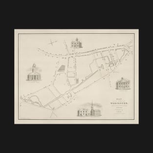
This is a vintage map of Worcester Massachusetts originally produced in 1829.
Tags: worcester massachusetts, worcester map, map of worcester, worcester, old worcester map
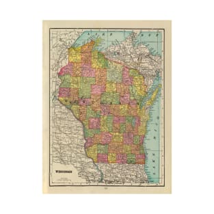
This is a vintage map of Wisconsin originally produced in 1909.
Tags: antique map of wisconsin, wisconsin lover, i heart wisconsin, i love wisconsin, wisconsin geography
This is a vintage map of Wisconsin originally produced in 1865.
Tags: geography of wisconsin, wisconsin cartograph, historical wisconsin map, vintage map of wisconsin, wisconsin lover
This is a vintage map of Malden, Revere, Everett Chelsea, East Boston and Winthrop Massachusetts originally produced in 1897.
Tags: chelsea ma map, winthrop ma map, east boston, everett massachusetts, revere massachusetts
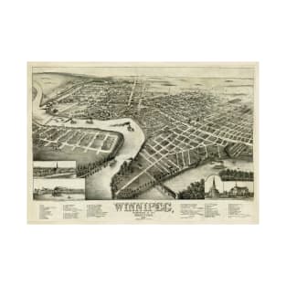
This is a vintage pictorial map of Winnipeg Canada originally produced in 1881.
Tags: winnipeg, atlas of winnipeg, map of winnipeg, winnipeg atlas, winnipeg map
This is a vintage map of the Windward Islands of the Caribbean originally produced in 1842.
Tags: windward islands, west indies atlas, historic west indies, windward islands atlas, old windward islands map
This is a vintage map of Ocean Trade Winds originally produced in 1898.
Tags: ocean winds chart, ocean winds atlas, oceanic trade winds, oceanic map, meteorology map
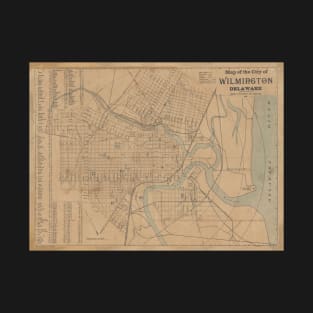
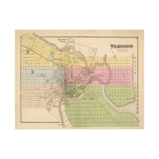
This is a vintage map of Wilmington Delaware originally produced in 1898.
Tags: vintage wilmington map, geography of wilmington, old wilmington map, history of wilmington, wilmington de
This is a vintage map of Wilmington Delaware originally produced in 1868.
Tags: old wilmington map, vintage wilmington map, historical wilmington map, antique wilmington map, map of wilmington
This is a map of Williamsburg Virginia originally produced in 1981.
Tags: williamsburg, williamsburg va, williamsburg city map, city of williamsburg, williamsburg virginia
This is a vintage illustration of a wild boar originally produced in 1888.
Tags: wild boar illustration, wild boar artwork, wild boar, wild pig, wild swine
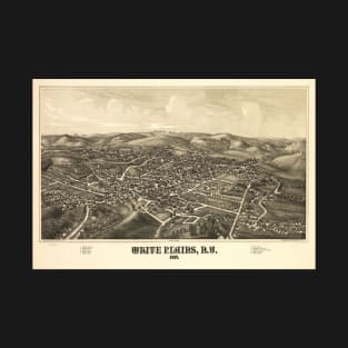
This is a vintage pictorial map of White Plains New York produced in 1887.
Tags: map of white plains ny, old map of white plains, historical white plains map, historical map of white plains, antique white plains map
This is a vintage map of White Plains New York originally produced in 1881.
Tags: map of white plains, white plains new york map, white plains new york, white plains map, old white plains map
This is a vintage map of White Plains New York originally produced in 1868.
Tags: map of white plains, white plains map, white plains new york, white plains new york map, white plains ny map
This is a vintage map of the White Mountains originally produced in 1858.
Tags: white mountains nh map, geography of the white mountains, i heart the white mountains, i love the white mountains, vintage white mountains map
This is a vintage map of World War I conquest ambitions of Germany originally produced in 1917.
Tags: wwi central powers, wwi central powers map, germany during wwi, first world war atlas, first world war
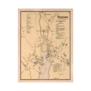
This is a vintage map of Westport Connecticut originally produced in 1867.
Tags: historical westport ct map, westport history, map of westport ct, westport ct map, antique westport ct map
This is a map of West Virginia originally produced in 1984.
Tags: west virginia geography, west va atlas, west virginia cartograph, west va chart, west virginia chart
This is a vintage map of West Virginia Natural Resources originally produced in 1899.
Tags: west va coal, coal in west va, resource map of west va, old west virginia geoloy map, west va resource atlas
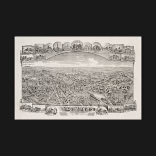
This is a vintage pictorial map of West Medford Massachusetts originally produced in 1897.
Tags: medford, map of medford, medford atlas, boston suburb, medford map
This is a vintage map of the Caribbean Islands originally produced in 1700.
Tags: geography of the caribbean, caribbean cartograph, caribbean atlas, historical caribbean map, vintage caribbean map
This is a vintage map of Wesel Germany originally produced in 1629.
Tags: vintage wesel map, historic wesel map, wesel germany atlas, wesel atlas, antique wesel map
This is a vintage map of Wellington New Zealand originally produced in 1841.
Tags: wellington map, wellington nz map, wellington atlas, wellington chart, capital of new zealand
This is a vintage map of Colonel Washington's route during the French and Indian War originally produced in 1932.
Tags: colonel washington routes, french and indian war, french and indian war map, french and indian war atlas, colonel washington military campaign
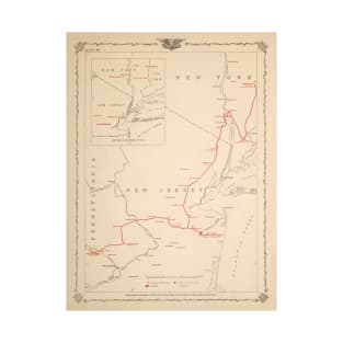
This is a vintage map of General Washington's New Jersey Military campaign originally produced in 1932.
Tags: general washington, washingtons campaign, george washington, nj history, general washingtons campaign
This is a vintage map of George Washington's Boyhood home originally produced in 1932.
Tags: mapmaker george washington, george washington homestead, george washington surveyor, american founding fathers, george washington mapmaker
This is a vintage map of Washingon States Floral Biome originally produced in 1906.
Tags: washington state biomes, washington state flowers map, old washington state map, flowers of washington state, washington state atlas
This is a vintage map of Washington DC originally produced in 1968.
Tags: vintage map of washington dc, vintage washington dc map, historical washington dc map, washington dc, washington dc satellite street map
This is a vintage map of Washington DC originally produced in 1838.
Tags: old washington dc map, washington dc, washington dc geography, map of washington dc, geography of washington dc
This is a vintage map of the DC national Mall originally produced in 1915.
Tags: map of the dc mall, old washington dc map, washington dc mall map, vintage washington dc map, national mall atlas
This is a vintage map of defenses and forts around Washington DC originally produced in 1895.
Tags: washington dc map, washington dc, dc map, washington dc atlas, dc atlas
This is a vintage pictorial map of Washington DC originally produced in 1915.
Tags: cartograph of washington dc, old map of dc, vintage map of dc, washington dc, map of washington dc
This is a vintage map of Washington DC originally produced in 1836.
Tags: washington dc cartograph, old map of dc, cartograph of washington dc, geography of washington dc, historical washington dc map
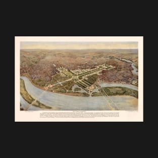
This is a vintage map of General Washington's Military campaign across the east coast.
Tags: george washington map, merican revolution battlefields, revolutionary war chart, george washington routes, george washington
Already have an account? Log in.