Normandy campaign map, 1944 (C026/8911) Long Sleeve T-Shirt
Historical Long Sleeve T-Shirt
designed and sold by SciencePhoto
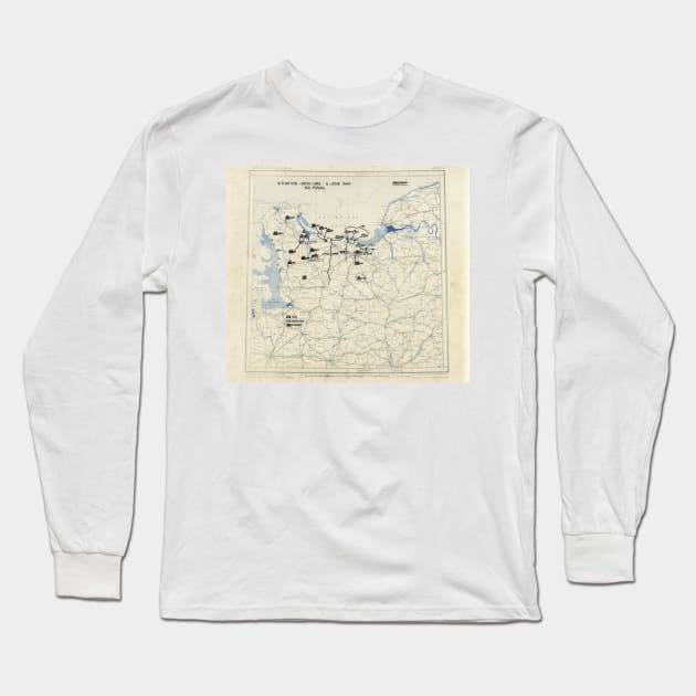
Normandy campaign map. Military map showing the presumed location of Allied (US and British) and Axis (German) forces soon after the D-Day Landings of 6 June 1944 on the coast of Normandy, north-western France. This was part of a massive invasion that would liberate Europe and lead to the Allied victory in World War II. This map, timed at 24:00 hours, shows the situation as understood by the operations staff (G-3) of the First United States Army Group (FUSAG), and later the Twelfth United States Army Group. These maps and reports were used by US commanders to evaluate the campaigns and to plan future strategies.

More Normandy campaign map, 1944 (C026/8911) Products
People Love TeePublic!
Not what you're looking for?
Try another search.

Product Quality
Our Production Team establishes the highest quality standards for third-party printers who participate in the marketplace to ensure that every product sold is perfect.

Historical Long Sleeve T-Shirt FAQ
UPS MI Domestic (6-8 Business Days)
FedEx 2-Day (4-6 Business Days)
Estimates include printing and processing time.More Shipping Info
We want you to love your order! If for any reason you don't, let us know and we’ll make things right.Learn More
Similar to Normandy campaign map, 1944 (C026/8911) Long Sleeve T-Shirt
More Historical products
Customers Also Search
More content to explore
Artist's Applied Tags
Trending Tags
The links above have been automatically generated based on tag usage by third-party designers on the TeePublic platform.