Vintage illustration patriotism design featuring a lady who has since become known as Rosie the Riveter. "We Can Do It!" is an American World War II wartime poster featuring an inspirational image to boost female worker morale.
Vintage illustration patriotism design featuring a lady who has since become known as Rosie the Riveter. "We Can Do It!" is an American World War II wartime poster featuring an inspirational image to boost female worker morale.
Tags:
equal rights, equality, feminisim, feminist, military
United StatesThe first page of the Constitution of the United States of America.
We the People of the United States, in Order to form a more perfect Union, establish Justice, insure domestic Tranquility, provide for the common defense, promote the general Welfare, and secure the Blessings of Liberty to ourselves and our Posterity, do ordain and establish this Constitution for the United States of America.
Tags:
1st amendment, 2nd amendment, america, americana, bill of rights
Vintage illustration featuring Washington Crossing the Delaware, 1851 by Emanuel Leutze. It commemorates General George Washington's crossing of the icy Delaware River during the American Revolutionary War with military soldiers carrying the American Flag on the night of December 25th, 1776. That historical action was the first move in a surprise attack against the Hessian forces at Trenton, New Jersey in the Battle of Trenton. The flag of the United States of America at this time was not the current stars and stripes that is pictured, the historically accurate flag would have been the Grand Union Flag, officially hoisted by Washington himself on January 2, 1776.
Tags:
american flag, american revolution, crossing the delaware, delaware river, general washington
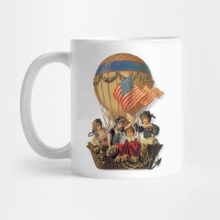
Vintage illustration Victorian patriotic image featuring children flying in a hot air balloon with the words, "Safe Journey" on a banner on the balloon. A United States of America flag is blowing in the wind. A fun design to help celebrate patriotism, freedom and the American Independence!
Tags:
4th of july, american flag, children, dirigible, fourth of july
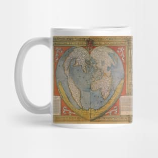
A Modern and Complete Map of the World by the Royal Mathematician Oronce Fine of the Dauphiné, 1534. Orontius Finnaeus. Recens et integra orbis descriptio. Orontius F. Delph Regi mathematic facebiat
Bernhard von Breydenbach made a pilgrimage to the Holy Land in 1483. The country is seen from the west (with a pilgrim's vessel near the coast at Jaffa) towards the east. Jerusalem is seen from The Mount of Olives westward, since this is the best viewing angle of the Holy City.
Tags:
antique map, bernhard von breydenbach, breydenbach, holy land, israel
Antique Map of the Americas by John Speed, 1626. America with those known parts in that unknowne worlde both people and manner of buildings discribed and inlarged by John Speed, 1626.
The Story of Exodus on Willem Janszoon Blaeu's Antique Map of the Holy Land, 1629. The map shows the aftermath of Moses and the children of Israel crossing the Red Sea, with Moses atop a rock at the right, watching the closing of the Sea and Pharaoh's army's inundated. A scene shows the encampment at the foot of Mount Sinai, with Moses in the glow of the burning bush, receiving the Ten Commandments. Terra Sancta quae in Sacris Terra Promissionis Olim Palestina
Tags:
antique maps, cartographers, cartography, exodus, israel
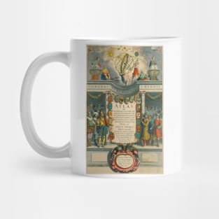
Frontispiece for 'The Mariner's Mirror' written by Lucas Jansz Waghenaer, 1588. An atlas of nautical charts and sailing directions with instructions for navigation. It was the first of its kind in the history of maritime cartography. A sea-atlas comprised charts, sailing directions, coastal views and navigational tables of the European coasts from Gibraltar to North Cape.
Antique map of the Western Hemisphere featuring the Americas originally made by Michael Mercator in 1595. America sive India Nova. The inserts show Cuba, Haiti and the Gulf of Mexico. Acanthus leaves surround the map.
Antique Old World Map by Joan Blaeu, c. 1630. The Nova Totius Terrarum Orbis Geographica Ac Hydrographica Tabula or “A New Geographic and Hydrographic Depiction of All the Lands of the World” was created by Willem Blaeu in Amsterdam in 1630.
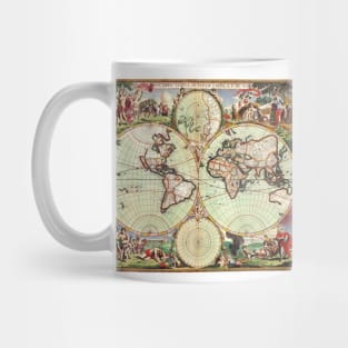
Antique old world double hemisphere map by Joan Blaeu, 1662. Nova Et Accuratissima Totius Terrarum Orbis Tabula. Auctore Ioanne Blaeu. Featuring allegorical figures along the bottom depicting the four seasons, celestial figures along the top, and portraits of the astronomer Galileo Galilei in the upper left and Tycho Brahe in the upper right.
Nova Orbis Tabula in Lucem Edita by Frederick de Wit, c. 1665. Antique old world map featuring a double hemisphere with two polar projections and scenes of the four seasons and signs of the zodiac in the corners.
Antique map of the Turkish Empire and Ottoman Empire by Frederick de Wit featuring the Eastern Mediterranean, Greece, and Italy in the West and Saudi Arabia, the Persian Gulf and Caspian Sea in the east and centered on Turkey and Cyprus.
Tags:
europe, frederick de wit, maps, mediterranean, mercator
Bird's eye view of Boston and Environs from 1905. The map shows railroad routes and Boston waterways. Islands are labeled and lighthouses indicated. Vintage bird's eye view map of historic Boston Massachusetts and the landscape of the surrounding areas. Boston was founded in 1630, it is one of the oldest cities in the U.S. and played a key role in history in the American Revolution.
Tags:
american revolution, antique map, boston harbor, environs, landscape
Bird's eye view of Memphis, Tennessee in Shelby County 1870. Memphis was established along the high banks of the Mississippi River in the early 1800's. Memphis was an important cotton and lumber trading center in its early years.
Tags:
antique map, birds eye view, city map, landscape, mississippi river
Bird's eye view of Louisville, Jefferson County in Kentucky in 1876. Louisville was established in the late 1700's along the Ohio River. The river falls made it necessary to off-load riverboat cargo at this point until Beargrass Creek was formed into an alternate route. The early community prospered as a high bank riverfront trading center, with local farms producing wheat, oats, corn and many varieties of fruit for exportation. The salt trade was also very important in Louisville.
Tags:
antique map, city map, historic, history, jefferson county
The Tennessee Centennial and International Exposition was an exposition held in Nashville, Tennessee from May 1 till October 31, 1897 in what is now Centennial Park.
Vintage illustration bird's eye view of our nations Capitol, Washington DC in 1916. The Arlington Bridge crosses over the Potomac River, also seen is the Lincoln Memorial, the Washington Monument and the United States Capitol Building.
Vintage illustration antique map of London, England by Johannes de Ram, 1689. Londini Angliae Regni Metropolis Delineatio Novissima & Accuratissima Autore Ioanne De Ram. The map includes a 10 point key in the top left corner bearing the names of Southwark landmarks, and a 148 point key in the top-right with the names of locations on the other side of the Thames River. The smaller title contained in a classical cartouche; the arms of London with dragon supporters. The bottom right has portraits of William and Mary, along the bottom is a view of London and the Thames River shortly after the fire. The map celebrates King William III and Queen Mary II's ascent to the English throne after the Glorious Revolution.
Tags:
antique map, england, great britain, king william iii, landmarks
Vintage illustration antique Town Plan of Lisbon, Portugal, 1598 with ships in the harbor by topo-geographers and cartographers Georg Braun and Franz Hogenberg. Together they edited the Civitates orbis terrarum, which contains 546 prospects, bird's-eye views, and maps of cities from Europe and all around the world.
Tags:
antique map, capitol city, cartographers, city map, europe
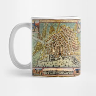
Vintage illustration aerial antique street map featuring a town plan of the European city of Amsterdam, the Netherlands, in the northern province of Holland. By cartographer Gerardus Mercator, 1633. There are ships in the harbor, streets, buildings and a wall surrounding the city for protection. Decorative insets feature landmarks and buildings of interest.
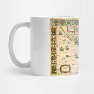
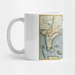
Vintage illustration antique South Asian map by Jodocus Hondius for the Gerardus Mercator Atlas, 1606. India Orientalis. This old world map of southeast Asia extends from India to the coasts of Southern China with the Pearl River Estuary, Canton and Formosa, it also includes all of the Malay peninsula and Indochina, northern Borneo and the Philippines, Japan and China. The decorative detail includes a large sea monster and an oriental junk in the Bay of Bengal as well as fine scroll work title and scale cartouches.
Tags:
antique maps, atlas, bay of bengal, borneo, cartouche
Vintage illustration antique map from the United States of America Travel Bureau, department of the interior. Many symbols across the map representing various regions. Also showing our border countries of Mexico and Canada. Titled "See America." A decorative border with Native American designs surrounds the map.
Tags:
antique map, canada, department of the interior, map, mexico
Vintage illustration bird's eye view of the streets of Saint Louis on the Mississippi River in 1859. St. Louis is a major U.S. port in the state of Missouri and is built along the western bank of the Mississippi River, on the border with Illinois. St. Louis was founded in 1764 by French fur traders Pierre Laclède and Auguste Chouteau, and named after Louis IX of France.
Tags:
aerial map, antique map, birds eye view, city map, mississippi river
Vintage illustration antique old world map by Johannes Schnitzer von Arnsheim. This antique world map is part of famed cartographer Nicolaus Germanus’ wonderful rendition of Ptolemy’s ‘Cosmographia’ of 1482. The artist responsible for the woodcut map identifies himself at the top of the world map as Johannes of Arnsheim, making it the earliest datable printed map to have a signature.
Vintage illustration antique map of the City of Washington D. C. A bird's eye view from the Potomac River looking north. Originally published by Currier & Ives, 1892. Aerial view of several Washington DC landmarks including the Washington Monument and the Capitol Building. Ships and boats are sailing in the seaport harbor.