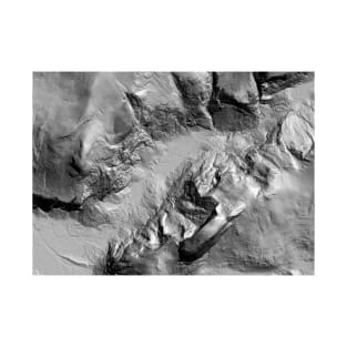
Hillshade map of Yosemite Valley
This material is based on data and processing services provided by the OpenTopography Facility with support from the National Science Foundation under NSF Award Numbers 1226353 & 1225810.
Lidar data acquisition and processing completed by the National Center for Airborne Laser Mapping (NCALM - http://www.ncalm.org). NCALM funding provided by NSF's Division of Earth Sciences, Instrumentation and Facilities Program. EAR-1043051.
https://doi.org/10.5069/G9D798B8
Tags:
valley, half dome, climbing, usa, california
Elevation map of Southern Norway
Elevation Data Source: Shuttle Radar Topography Mission (SRTM) 1 Arc-Second Global
https://lta.cr.usgs.gov/SRTM1Arc
Data downloaded from the USGS Earth Explorer site: http://earthexplorer.usgs.gov/